Category Archives: Uncategorized

CBSNews.com: Marine Food Chain Seen at Risk After Oil Spill

http://www.cbsnews.com/stories/2010/05/06/tech/main6464474.shtml

 As Americans anxiously wait for a slick in the Gulf of Mexico to wash up along the coast, globules of oil are already falling to the bottom of the sea, where they threaten virtually every link in the ocean food chain, from plankton to fish on dinner tables everywhere.

Meanwhile, a giant concrete-and-steel box seen as the best short-term solution to bottling up the disastrous oil was loaded onto a boat Wednesday and the 100-ton (90-metric ton) contraption began its journey to the leak site about 50 miles (80 kilometers) off the Louisiana coast.

Oil has been gushing into the Gulf of Mexico at a rate of at least 200,000 gallons (755,000 liters) a day since an offshore drilling rig exploded last month and killed 11 people. Officials hope to lower the concrete-and-steel box the size of a four-story building to the bottom of the sea by week’s end to capture some of the oil.

For marine life, though, the damage is already done, experts said.

“The threat to the deep-sea habitat is already a done deal it is happening now,” said Paul Montagna, a marine scientist at the Harte Research Institute for Gulf of Mexico Studies at Texas A&M University-Corpus Christi.

Hail-size gobs of oil the consistency of tar or asphalt will roll around the sea’s bottom, while other bits will get trapped hundreds of feet (meters) below the surface and move with the current, said Robert S. Carney, a Louisiana State University oceanographer.

Food Chain Impact

Scientists say bacteria, plankton and other tiny, bottom-feeding creatures will consume oil, and will then be eaten by small fish, crabs and shrimp. They, in turn, will be eaten by bigger fish, such as red snapper, and marine mammals like sea turtles.

The petroleum substances that concentrate in the sea creatures could kill them or render them unsafe for eating, scientists say.

“If the oil settles on the bottom, it will kill the smaller organisms like the copepods and small worms,” Montagna said. “When we lose the forage, then you have an impact on the larger fish.”

Making matters worse for the deep sea is the leaking well’s location: It is near the continental shelf of the Gulf where a string of coral reefs flourish. Coral is a living creature that excretes a hard calcium carbonate exoskeleton, and oil globs can kill it.

CBSNews.com Special Section: Disaster in the Gulf
Gulf Oil Spill, by the Numbers

The reefs are colorful underwater metropolises of biodiversity, attracting sea sponges, crabs, fish, algae and octopus.

“In my mind, they are at least as sensitive to contamination to oil as coastal habitat,” said James Cowan, an oceanographer at Louisiana State. “They are in deeper water, so they are kind of out of sight, out of mind.”

There are other important habitats in shallower waters, such as an ancient oyster shell reef off the Mississippi and Alabama coasts. It is a vital nursery ground for red snapper and habitat for sponges, soft corals and starfish.

Scientists are watching carefully to see whether the slick will hitch a ride to the East Coast by way of a powerful tide known as the “loop current,” which could send the spill around Florida and into the Atlantic Ocean. If that happens, the oil could foul beaches and kill marine life on the East Coast.

“Once it’s in the loop current, that’s the worst case,” said Steve DiMarco, an oceanographer with Texas A&M University-College Station. “Then that oil could wind up along the Keys and transported out to the Atlantic.”

The Gulf ecosystem is already stressed by fertilizer and other farm runoff from the Mississippi River and the loss of wetlands to erosion and development. About 2,100 square miles (1,345,000 acres) of wetlands have disappeared since the 1930s in southern Louisiana.

Every summer, algae caused by fertilizer runoff sucks up the oxygen in a large patch of the Gulf, creating a “dead zone” from which all sorts of sea creatures must escape. This year, they will be swimming into waters fouled by the oil spill.

“We’re always wondering when we may reach the point where straw breaks the camel’s back,” Montagna said. “At some point you have to wonder if we will see catastrophic losses.”

ABC-7.com: Mason-Dixon released a poll yesterday showing that FL voters now oppose offshore drilling

http://www.abc-7.com/global/story.asp?S=12445470&clienttype=generic&mobilecgbypass
Florida voters re-think offshore oil drilling

In the wake of the Deepwater Horizon disaster in the Gulf of Mexico, Florida voters have reversed their view on drilling off of the state’s coast, according to new poll released by Mason-Dixon.

Statewide, only 35% currently support offshore drilling, while a 55% majority are now opposed to it.

That is in stark contrast to a poll conducted 11 months ago, where 55% of the state’s voters were in favor of offshore drilling and only 31% were opposed.

Support for drilling peaked at 61% in August 2008, amid the soaring price of gasoline nationwide and rising concerns about energy independence.
OFFSHORE DRILLING SUPPORT SupportOpposeUnd.August 200861%32%7%April 200959%28%13%June 200955%31%14%May 201035%55%10%
Mason-Dixon analyst Brad Coker notes opposition is now widespread, with strong majorities opposed in four of the state’s five major regions. A small plurality in North Florida (47%) is still in favor of drilling, but opposition is between 54% and 60% in the rest of the state.

Coker says Republicans are now the only group to still favor drilling (57%), but even that support has dropped significantly. In June 2009, 80% of GOP voters backed it, but that support has now declined by 23-points. Additionally, support among Democrats has dropped from 36% to 19% and independents who favor it slid from 51% to 27%.

HOW THE POLL WAS CONDUCTED
This poll was conducted by Mason-Dixon Polling & Research, Inc. of Washington, D.C. from May 3 through May 5, 2010. A total of 625 registered voters were interviewed statewide by telephone. All stated they vote regularly in state elections.

Those interviewed were selected by the random variation of the last four digits of telephone numbers. A cross-section of exchanges was utilized and quotas were assigned to reflect voter turn-out by county.

The margin for error, according to standards customarily used by statisticians, is no more than plus or minus 4 percentage points. This means that there is a 95 percent probability that the “true” figure would fall within that range if all voters were surveyed. The margin for error is higher for any subgroup, such as a gender or party grouping.

special thanks to Richard Charter

McClatchy News Service: Since spill feds have given 27 waivers to oil companies in Gulf

McClatchy New Service
May 8, 2010

 http://www.mcclatchydc.com/2010/05/07/v-print/93761/despite-spill-feds-still-giving.html
Marisa Taylor | McClatchy Newspapers
last updated: May 08, 2010 03:29:10 AM

WASHINGTON  Since the Deepwater Horizon oil drilling rig exploded on April 20, the Obama administration has granted oil and gas companies at least 27 exemptions from doing in-depth environmental studies of oil exploration and production in the Gulf of Mexico.

The waivers were granted despite President Barack Obama’s vow that his administration would launch a “relentless response effort” to stop the leak and prevent more damage to the gulf. One of them was dated Friday  the day after Interior Secretary Ken Salazar said he was temporarily halting offshore drilling

The exemptions, known as “categorical exclusions,” were granted by the Interior Department’s Minerals Management Service (MMS) and included waiving detailed environmental studies for a BP exploration plan to be conducted at a depth of more than 4,000 feet and an Anadarko Petroleum Corp. exploration plan at more 9,000 feet.

“Is there a moratorium on off shore drilling or not?” asked Peter Galvin, conservation director with the Center for Biological Diversity, the environmental group that discovered the administration’s continued approval of the exemptions. “Possibly the worst environmental disaster in U.S. history has occurred and nothing appears to have changed.”

MMS officials said the exemptions are continuing to be issued because they do not represent final drilling approval.

To drill, a company has to file a separate application under a process that is now suspended because of Salazar’s order Thursday.

However, officials could not say whether the exemptions would stand once the moratorium is lifted.

MMS’ approvals are expected to spark new criticism of the troubled agency and the administration’s response to the spill.

Salazar announced Thursday that there’d be no new offshore drilling until the Interior Department completes the safety review process requested by Obama. The department is required to deliver the report to the president by May 28.

Given the MMS approvals, however, Galvin said the administration’s pledge appears disingenuous.

“It looks to me like they’re misleading the public,” he said.

MMS spokesman David Smith said his agency conducts a thorough review before it determines whether to grant such exemptions.

“It’s not a rubber stamp,” he said.

BP did not return calls for comment.

MMS set out rules that allow for the exemptions from some environmental requirements under the National Environmental Policy Act (NEPA) as long as the sites in question are not relying on new or unusual technology, or within high seismic risk areas, or within the boundaries of marine sanctuaries or in regions with hazardous bottom conditions. MMS also assesses the impact on biological and archeological resources.

In the gulf, Smith said, MMS has a “wealth of environmental data” from studies of the region that it can rely on when reviewing the requests from the energy firms.

That’s why oil and gas companies that were given the exemptions said the approvals were routine and shouldn’t have raised any environmental concerns.

Apache Corp. said it was granted four exemptions for updating production equipment and drilling wells on existing sites and for drilling in the vicinity of an existing site. Appropriate environmental studies were conducted before the purchase of the leases for those sites, said Bill Mintz, a spokesman with Apache.

“We followed the procedures and the government didn’t change the procedures,” said Mintz. “The decisions are made according to rules in a framework that has been established.”

Anadarko also cited a previous environmental assessment of a site where it applied for a waiver.

“Protecting the environment and the safety of our personnel are our highest priorities,” said John Christiansen, a Anadarko spokesman, Walter Oil & Gas also received one for a survey of an existing site off the coast of Louisiana.
Environmentalists, however, say that MMS’ checklist for determining whether to grant such exemptions are far too broad and relies on sweeping environmental impact studies that are undertaken before the purchase of leases.

Holly Doremus, a professor of law at Boalt Hall, University of California at Berkeley, said MMS has had a culture of minimizing environmental reviews of oil and gas development dating back to its inception in 1982.

“That’s related to the fact that oil companies have a great deal of power over MMS and there hasn’t been much oversight,” she said. “My guess is that these things are routinely being signed off on as categorical exclusions even though they deserve a closer look.”

Other companies that received the waivers include: Shell, Kerr-McGee Oil & Gas Corporation, Royal Exploration Company, Inc., MCX Gulf of Mexico, Tana Exploration Company, Tarpon Operating & Development, Rooster Petroleum, Phoenix Exploration Company, and Hall-Houston Exploration III.

Tracy L. Austin, spokeswoman for Mitsubishi International Corporation, which owns MCX Gulf of Mexico, said she could not comment on MMS’ handling of the exemptions overall.

“While we understand that the MMS has come under criticism for failing to adequately regulate the industry, with respect to our operations, we believe the MMS has acted responsibly,” she said.

Lawmakers from both sides of the aisle have already called for reform of MMS after news that BP was granted on exemption for the Deepwater Horizon site. That waiver was first reported by the Washington Post.

“If the conclusion is we need new regulation to prevent something like this from happening again, we’d welcome that because we believe we operate in a safe and environmentally responsible manner,” said Mintz with Apache. “But right now, the current rules say certain activities can proceed based on the studies that have been done.”

In 2008, a series of government watchdog reports implicated a dozen current and former employees of the MMS in inappropriate or unethical relationships with industry officials.

The reports described “a culture of substance abuse and promiscuity” in the Royalty in Kind program, in which the government forgoes royalties and takes a share of the oil and gas for resale instead. From 2002 to 2006, nearly a third of the RIK staff socialized with and received gifts and gratuities from oil and gas companies.

St. Pete Times: Loop current could bring oil to the Florida Keys, but keep it away from Tampa Bay

http://www.tampabay.com/news/science/loop-current-could-bring-oil-to-the-florida-keys-but-keep-it-away-from/1092618

By Curtis Krueger, Times Staff Writer
In Print: Wednesday, May 5, 2010

Scientists are keeping their eyes on a giant stream of warm water that loops around the Gulf of Mexico to learn if oil will wash onto Florida’s shores.

This “loop current” gets a bit of publicity during hurricane season, but it has never been more important to Florida than now.

If oil slops onto the Florida Keys, you can probably blame the loop current for sending it there. But if oil cruises harmlessly past Tampa Bay, you can probably thank the loop current for that, too.

To understand the loop current better, the St. Petersburg Times spoke on Tuesday with Frank E. Muller-Karger, a professor at the University of South Florida’s College of Marine Science.

What protects Tampa Bay if oil gets into the loop current and flows alongside the Florida Shelf?

“What protects us is the distance between us and the edge of the shelf. The West Florida Shelf is very wide (more than 100 miles), at least off Central Florida. It becomes very narrow off of the Florida Keys. … So as the loop current flows south toward the Florida Keys and starts bending into the Florida Straits, that shelf becomes very narrow and anything in the loop current will be very close to the coast.”

What would have to happen for that oil to get to the Tampa Bay area?

“There’s probably two scenarios. One is that the oil creeps along the coast, the Panhandle, and slowly moves south along the coast and that would take probably weeks. … It (would) be a mess for northern Florida and the Big Bend area.

“If the oil gets caught in the loop current itself, it will shoot down to the Florida Keys. (That will take about) … a week to 10 days. For it to move from the loop current … across the shelf (toward Tampa Bay) you would have to have very strong winds blowing from the west to the east. … You would need to have a persistent, weeklong wind.

“But anything, once it gets into the Florida Shelf and it’s there, it’ll get blown around. It may disperse, it may evaporate, it’ll certainly mix around and it’ll become more dilute.”

How likely is it that we could see some effect of this oil on the west coast of Florida?

“The Panhandle is, I think, a certainty. The middle of Florida, say Pinellas County, I think at the moment, the next week or two, is unlikely. Longer than that, if they cannot get this under control … there’s many, many variables that we have to consider before we can say that it’s going to happen here in Pinellas County.

“The most likely area where it may have an impact if it gets caught in the loop current and if it doesn’t burn off … in that week of transit, it may end up in the Dry Tortugas, maybe or one of the Keys and then get into Florida Bay or go up the east coast. The question is, is that going to be a trickle of oil or is it going to be big patches of oil? We don’t know that either.”

Is the oil in the loop current yet?

“The oil is not in the loop current yet. … I think there is a likelihood the longer the spill goes on, that it will eventually get into the loop current.”
[Last modified: May 05, 2010 07:03 AM]

Skytruth.org: Gulf Oil Spill-Radar Satellite Image May 8, 2010

http://blog.skytruth.org/2010/05/gulf-oil-spill-radar-satellite-image.html

Saturday, May 8, 2010

Our friends at CSTARS just posted this stunning image. Taken by the Canadian-operated radar satellite, RADARSAT-2, it clearly shows oil slicks and sheen spread across a wide area (about 5,025 square miles, or 13,000 km2) in the Gulf of Mexico early this morning (May 8):

RADARSAT-2 image of the Gulf of Mexico, May, 8, 2010 – Source: CSTARS

We’ve added some analysis to help you armchair interpreters. Oil slicks look dark on radar images because the oil reduces the surface tension of the water, dampening (smoothing out) the small wavelets that normally roughen up the surface of the ocean. But any smooth water will look dark on radar, so not all dark patches are caused by oil:

RADARSAT-2 image with SkyTruth analysis, May 8, 2010.

UPDATE 5/8/10 7:00 pm – The first attempt to place a 70-ton containment box over the main leak failed today; the box has been moved aside and is being troubleshooted, and tar balls have begun to wash up in Alabama. The leak is continuing unabated, at a rate we calculate to be about 1.1 million gallons (26,500 barrels) per day – five times higher than the last official estimate (5,000 barrels per day) the Coast Guard made, before they quit making estimates a few days ago, admitting they had no accurate way to estimate the spill rate.

We estimate more than 18 million gallons of oil have spilled so far.

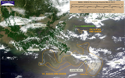
Now we can do a heads-up comparison of the RADARSAT-2 image with this MODIS/Terra image taken about four hours later. Still some clouds obscuring portions of the slick; observable slick and sheen spans about 4,100 square miles (10,624 km2). Fresh oil is apparent around the location of the leaking well; it seems to be carried to the southeast, then gets caught up in a counterclockwise gyre in the currents:

Posted by John at 4:08 PM