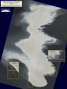
Detail from SkyTruth image showing response vessels and Gulf oil slick on April 25.
We just got a detailed ALI satellite image from NASA that was shot two days ago, on April 25, when the oil slick was about 817 square miles in size (it has since more than doubled to at least 1,800 square miles). You can see several response vessels working at the periphery of the slick. The magnitude of the job they have to do is plain to see.
See more in our growing image gallery for this incident (click below).
—
John Amos
John@skytruth.org
P.O. Box 3283
Shepherdstown, WV 25443-3283
phone: 304-260-8886
skype: skytruth.amos
*****************************************************************
SkyTruth: Satellite images and digital mapping for
environmental protection, education and advocacy
A 501(c)(3) nonprofit organization – http://www.skytruth.org
Learn more at the SkyTruth Blog – http://blog.skytruth.org
Browse our image galleries at Flickr – http://tinyurl.com/yd576ep
Follow us on Twitter for the latest – http://twitter.com/skytruth
