

Reef Relief's 1998 Cuba Expedition


If the biota, in the course of aeons, has built something we like but do not understand, then who but a fool would discard seemingly useless parts? To keep every cog and wheel is the first precaution of intelligent tinkering. Aldo Leopold, Round River, 1993.
Reef Relief Founders.com
ACKNOWLEDGEMENTS
This expedition was made possible through the generous support of Whitney Bailey and the Bailey Wildlife Foundation and through the efforts of our hosts in Cubathe Cuban Institute of Oceanography and Marina Hemingway. A personal thanks to our colleagues at the instituteDr. Rodolfo Claro, Dr. Pedro Alcolado, Lic. Angelita Corvea, Maria Elena Miravet, and all the staff at the Institute and to Institute Director Areces for his support of our agreement with the Institute to perform this multi-year survey of Cubas coral reefs. Special recognition is due to Commodore Escritch of the Marina Hemingway Yacht Club for his cooperation and to Dr. Roberto Balboa Perdomo for many of the necessary arrangements while we were in Havana.
The ongoing Reef Relief Photo Monitoring Survey has been made possible through the multi-year support of the Curtis and Edith Munson Foundation, the Turner Foundation, The Norcross Wildlife Foundation, the Henry Fund, the Chingos Foundation, the Lounsberry Foundation and the members of Reef Relief. The confidence of these foundations and individuals has made possible the growing database of change in the coral reefs of the Florida Keys, as well as those in Jamaica, Mexico, Puerto Rico, Bahamas and Cuba. The increased knowledge from this survey has led to a greater recognition of the tremendous dynamics that occur at coral reefs, along with a growing awareness of the extent of coral diseases, bleaching episodes, algal blooms, and episodic storm events on these biologically diverse marine ecosystems. This information has enhanced Reef Reliefs educational efforts and encouraged the protection of coral reefs through the inestimable value of first-hand documentation.
Craig Quirolo
Director of Marine Projects, Retired
Reef Relief
INTRODUCTION
The body of water between Cubas west coast and Mexicos Yucatan Peninsula, called the Yucatan Straits, is one of the most treacherous bodies of water in the Caribbean Sea. Shallow fringing coral reefs border both sides of this pass that is notorious for its strong northerly moving current. On its western shores, in Mexico and Belize, world class dive resorts have been built catering to divers anxious to see pristine coral reefs. On the eastern side of the Yucatan Straits begins a very long bank reef called Arrecifes Colorados that wraps around the north western end of Cuba stretching eastward to within 50 miles of Havana. In a setting very similar to the Florida Keys, a chain of islands called the Archipielago de los Colorados parallels the inside of this barrier reef. A channel between the keys and the reef spans the entire length of this Archipielago, making it possible to safely navigate inside the 120 mile long barrier reef. Very little information exists about the Archipielago de los Colorados or its associated reef, the Arrecifes Colorados. The most current information is covered in two recently published cruising guides about Cuba (Nigel Calders Cuba: a Cruising Guide and Simon Charless The Cruising Guide to Cuba).
In June of 1998, Craig and DeeVon Quirolo sailed to Havana in order to transit the inside passage of the Arrecifes Colorados on board their 30 foot sailboat, Stormy Weather. The goal of this expedition was to fulfill an agreement with the Cuban Institute of Oceanography to survey Cuban coral reefs through this second-year expedition. During the first expidition in 1997 the reefs at Cayo Cocos, Playa Flamingo and Maria la Gorda were surveyed. Our plan was to snorkel on as many of the shallow coral reefs in Arrecifes Colorados as time (June1-25) and weather would permit. Eight shallow reefs, Bahia Honda, Cayo Levisa, Puerto Esperanza, Cayo Jutias were surveyed during this expedition. The lower portion of the barrier reef bordering the Yucatan Straits was transited but not surveyed because of bad weather that prohibited diving.
The complete multi media report includes seven CD discs of slide images, five video tapes (covering all transects) with indexed time counts, notes from the log of Stormy Weather and various charts depicting the course of the expedition.
VIDEO TRANSECTS
The eight video transects included in this report were recorded during this expedition. At each reef a 60 meter transect line was established. Using a Hi-8 underwater video camera, the transect line was recorded looking down 90 degrees, perpendicular to the ocean floor. This 90 degree look down segment is used to determine percent of biotic coverage using a randomized point intersect method (Lapointe, Littler & Littler 1997 Proceedings of the 8th Annual Coral Reef Symposium, Panama). A 45 degree look down of the transect line is also recorded focusing in on close ups that will help in identifying subjects in the 90 degree look down. A random non-stop recording was made at many of the sites that gives the viewer a good idea of the overall conditions of each reef.
The results from the scoring of each transect were graphed and charted to compare coral vs macroalgae coverage
STILL IMAGES
Approximately thirty six 35mm color slides were taken at each transect site. The images are included in this report and are cataloged according to transect number, location and are numbered #1-#248. Each transect site has been scanned to CD disc format except T1 and T2 which share the same disc.
The images on the CD discs have been scanned at two different resolutions; 500Ddpi and at 200dpi and they are both Mac and PC readable.
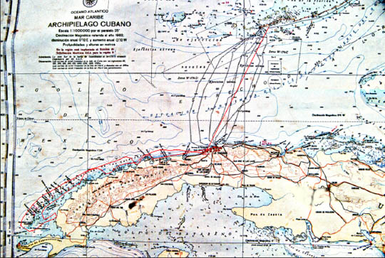

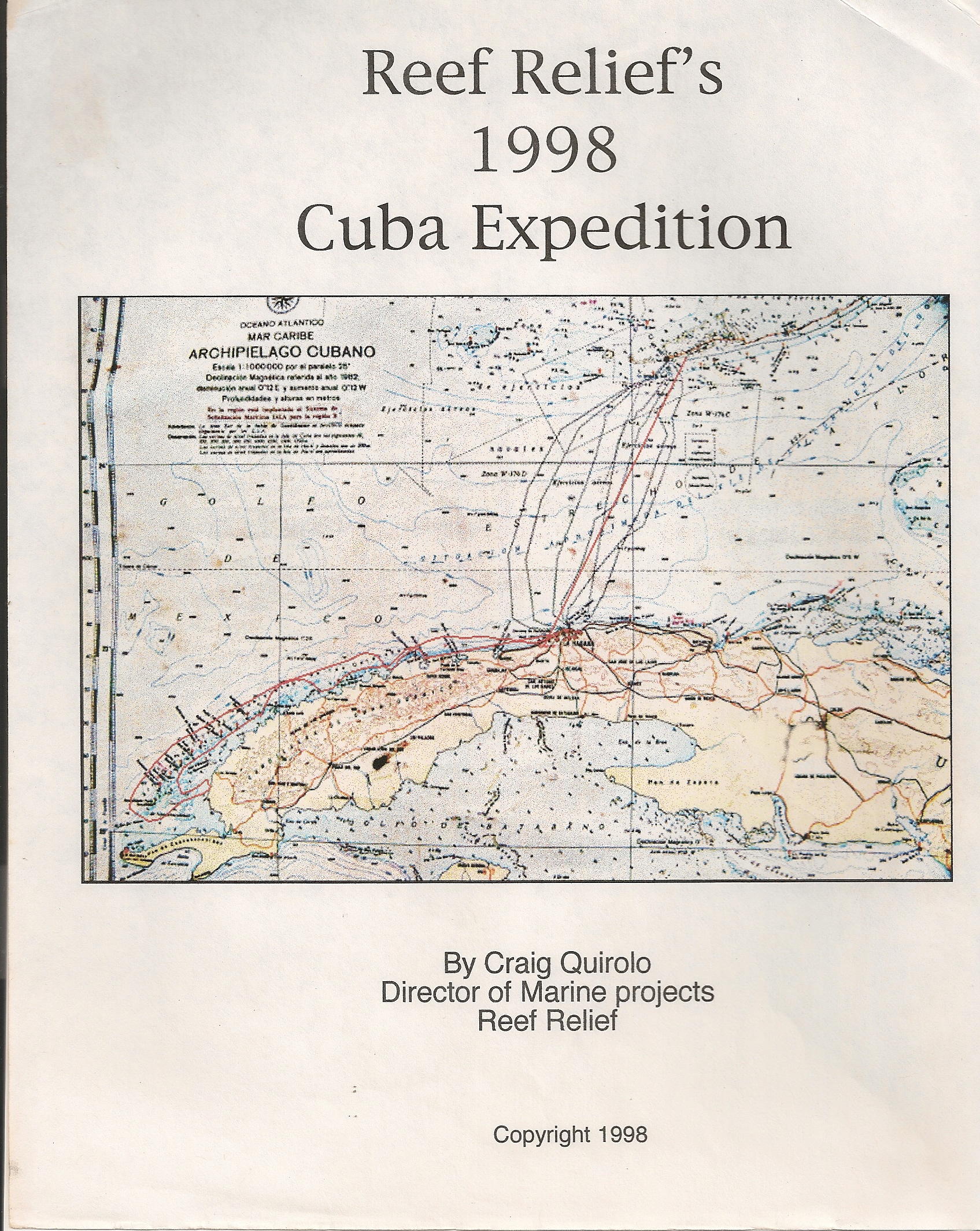
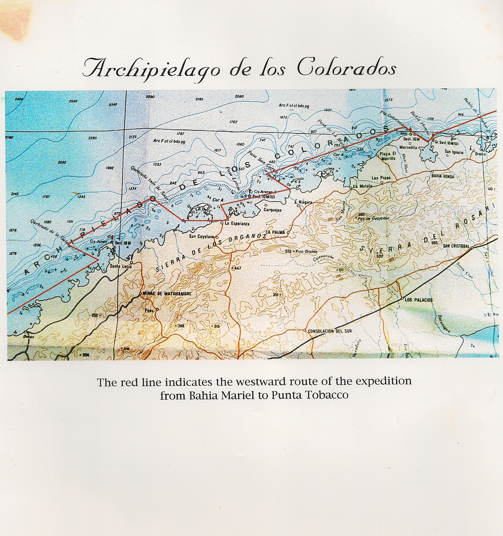
Above: Archipielago
de los Colorados
Above: CHART
Expedition Route